


PARAGLIDING sport is to take off by means of running from a high hill instead of plane with a parachute similar to free style jumping parachute on the first look. Parachute, which is lied on a inclined and high hill, is filled with air with the running of pilot and take off with pilot. Periods of the flights can continue for kilometers / hours in connection with experience of the pilot and performance of the materials used. Although it can be for single person, there is two persons ( tandem ) wings.
Paragliding , whose first trial had been made on 1940s, had been numerously modified till today, and lots of structural improvements which increase the flight period and security, had been performed. First paragliding was similar to free style diving parachute. It had turned into an aerophyl structure which has high raising power instead of its pressure enduring characteristic with changing in time. Paragliding parachute wing structure had reached to its appropriate shape for easy to take off, slowly descending ratio and good flying performance, beginning from 1980s.
Paragliding Sport in our country had been recognized with the discover by foreign pilots of Mount Baba in Fethiye, Ölüdeniz (Blue Lagoon) region at the beginning of 1990s, and actively started in university clubs initially. Being the most economical aerial vessel and being inside the natural sports, maintained it to be performed by a massive number of people today. ParaglidingParachute Sport, which does not require a special skill or much effort basically, is very easy and enjoying to do after a standard training. Paragliding training are organized by THK, university clubs and private clubs.
Some of the Flight Zones
The sport of paragliding involves taking off by means of running from a high hill with a parachute attached, similar to free style parachute jumping. The parachute itself, which is placed on the incline of a sufficiently high hill, is filled with air whilst the pilot runs to facilitiate take-off. Flight durations can last in terms of hours, dependent upon the experience of the pilot and the quality of the equipment used. Although paragliding can be enjoyed on an individual basis, flights can be also be taken in tandem.
Paragliding first emerged in the 1940s, and over the years, parachute design has been modified and structural improvements have been made in order to increase flight duration and improve safety. The first paragliding parachute design was similar to a free style diving parachute. Over time, it evolved into an aerophyl structure with high raising power instead of its pressure enduring characteristic. Wing structure reached its current stage of development during the 1980s, synonymous with easy take-off, a slow descending ratio and good flying performance as are known today.
At the beginning of the 1990s, international pilots discovered Mount Baba in Fethiye, Ölüdeniz (Blue Lagoon) and the activity actively took off in Turkey. Standard training can prepare almost anybody to participate in a tandem jump and the sport's simplicity has ensured that over the years its popularity has increased. In accordance, there are now a selection of sites at which paragliding can be enjoyed throughout Turkey.
Some of the Flight Zones
ÖLÜDENIZ - BABADAG
Location: Mount Baba, which is located in Ölüdeniz/Fethiye in the province of Muðla, is 7 km inside inland. It rises just behind the lagoon of Ölüdeniz and faces southward. The take off runway is reached via a 45 minute drive from Ölüdeniz.
Flight Season: Flights can be performed between April and October.
Regional Characteristics: Ölüdeniz, which is the first place where paragliding is performed in Turkey, has a world - wide fame. Its unique nature, sun and sea is enchanting thousands of national and foreign tourists every year, and has a structure appropriate for all kinds of outdoor activity. There is no transportation, accommodation and nutrition problems within the developed touristic center, region. Yacht tours are also drawing attention in the area. Mount Baba is preferred as trekking and camping area during summer and winter.
Take Off Runways: There are a total of three runways in Mount Baba. 1700 meters high south runway is appropriate for take off. 1800 meters high north runway is a little bit small and upright. Take off area of the 1900 meters high north peek runway is very comfortable. As 1700 meters high runway is taking the south wind just from the opposite side during the most part of the day, generally take off is made from here. Approximately 20 wings can be lied on very wide runway at the same time.
Landing Runway: Belcekiz beach at the coast of Ölüdeniz, is a long and very comfortable and secure landing runway with its width.
Meteorological Characteristics: During summer season, weather is stable. Sometimes during morning hours a north wind comes and take off is made from north runways into the valley. South runway faces a south wind, between 5 - 20 km. during most of the day hours.
Things that should be considered: Especially during the beginning and end of the season, climate change months weather can change rapidly and cloud can cover the take off area. On south runway, during the period till to the midday west wind coming from the west end of the mount, can create a false south wind and mislead.
DENIZLI - PAMUKKALE
Location: Pamukkale is at the feet of Mount Çökelen which is 21 km away from Denizli. As it is a touristik region all kinds of transportation is available to the region.
Flight Season: Flight can be made during all seasons with its warm climate.
Regional advantages: An ancient settlement region, Pamukkale is one of the most important tourism centers of our country where thousands of tourists are coming every year with its ancient ruins and travertine formed with the settlement of lime water.
There are two hills for take off:
Training Hill
Meteorological Characteristics: After sun rise, wind which can be sensed at south - west direction had blows mild till to the noon hours. Wind which increases its speed during noon hours slides to the west and nearly fully stops during sun set.
Take Off Runway: As 70 m high hill is low it is preferred for amateur flights. Due to the warm impacts of the underground waters in all of the region wind changes sensed within the region is not sensed here. By means of regular winds secure flights can be made during all of the year.
Landing Runway: Flights from the slope is ended at the plains of the region. Landing points are very secure due to not holding a handicap.
Things that should be considered: Though turbulence formed with the speeding up wind during the noon hours of the months when summer hot is lived most densely should be considered.
Dynamite Warehouse
Meteorological Characteristics: Hill, which is reign by western winds is especially appropriate for flight during morning hours. Strong thermal formations which begin around noon are maintaining long flights for experienced pilots.
Take Off Runway: Flight runway, which took its name from a former dynamite warehouse at the peek is 300 meters high. Slope which has a wide area for take off of two parachutes together easily, is at a point from where you can see all beauties of Pamukkale.
Landing Runway: Although you can land to the area at the end of flight track, you can also land securely to the helicopter runway at the entrance of travertine.
Things that should be considered: Turbulence formed during noon hours of summer months require maximum control and consideration during flights. You can face with turbulence at the end of take off runway during hard winds. Cross blowing wind causes asymmetrical close at parachute just after take off. Also ending of hill with high slope requires a very quick run for a successful take off.
ANKARA - GÖLBASI
Location: Transportation to Gölbasi region, which is 27 km. away from Ankara city center can be easily maintained from city center.
Regional Characteristics: Due to closeness to Ankara it is possible to benefit from all activities and possibilities within the city. It is the region where aerial clubs of universities in Ankara are training Paragliding . Gölbasi, is also a promenade place which draw attention of Ankara residents who want get away from city life goes for weekends.
Take Off Runway: Training hill which faces to a wide plain is very appropriate for hillside parachute training due its appropriate altitude and facing wind from all aspects.
BOLU - ABANT
Location: Abant Mountains, is 34 km. south of the Bolu city center. Asphalt 25 km. long Abant Lake road can be used for reaching. Road transport to Bolu, which is on the Ankara - Istanbul highway passing is very easy. For reaching Abant Lake minibuses departing from city center can be used.
Regional Characteristics: Dense rain forests surrounded Bolu city is appropriate for all kinds of tourism activity. Abant Lake, whose environment has a rich plant cover, is drawing attention as a picnic and resort place during summers and an appropriate place for winter sports during winter. Abant Lake surrounding accommodation and nutrition possibilities can be benefited.
Take Off Runway: Abant Mountains have more than one take off runways appropriate for hillside parachute. Generally it is performed on the hills surrounding Örencik Plateau, near to Abant Lake, wide, plain and fully covered with grass.
EGIRDIR
Location: There are road and railroad transportation in Eðirdir, which is 60 km. away from Isparta. Local bus firms of Isparta are passing from Egirdir.
Regional Characteristics: Egirdir which is appropriate for lots of tourism activities with Eðirdir lake and island, has very appropriate hills for paragliding parachute. Süleyman Demirel University Aerial Club is performing training flights on these hills.
KAYSERI
Location: Ali Mountain on the territories of city of Kayseri, is 15 min. Away from city center. It can be driven up carefully. Or when you get off the bus at Ali Mountain plate with getting on to a bus, you can reach to the hill within 45 minutes by foot.
Regional Characteristics: World wide famous Cappadocia present, Kayseri is welcoming to thousands of tourists each year. Kayseri is serving possibilities to the other sportive tourism types such as skiing and cycling besides paragliding with its appropriate geography. Civil Aviation VIHE, is organizing training flights to Mount Ali.
Take Off Runway: It has an altitude difference of 600 to 750, and there are two take off runways of which one is appropriate to south winds and other one is north. Steep and smooth inclination of the hill is appropriate for hours of paragliding, but you should be careful in weathers with turbulence.
Landing Runways: There are easily landing areas in front of the hill.
ESKISEHIR / Inönü
There are facilities of Turkish Aviation Organization within Ýnönü Province which is 15 km west of Eskiþehir. North facing slopes of the province, are establishing very appropriate flight conditions with especially north winds during summer months. Courses organized by Turkish Aviation Organization are performed here.
ANTALYA / Aksu
Hill in Aksu province of Antalya is used as training hill by Akdeniz University, Avaiation Club. When you turn Perge ruins from Aksu turn of Antalya - Alanya road, and go for a 10 - 15 km. without entering Perge 40 - 50 m. high training hill is reached. Irrigation channel should be considered during flight.
Physical Conditions for Paragliding
For paragliding lower age limit is 16 and upper limit is 55. You can be flexible for upper age limit according to health condition. Kilo limit is minimum 40 kg, and maximum 130. Epilepsy, asthma, heart, waist and keel disordered persons can not participate to hillside parachute training. For participation to hillside parachute a form declaring that health conditions are appropriate is filled.
Parachute Types
Parachutes (wings) have various sizes and types according to weight of the pilot and flight type. Parachute used by light weighted pilot, is smaller in size than heavy pilot uses. There are 5 types of parachutes showing different performances according to the training taken and experience.
Wing Structure
Paragliding can be investigated at 4 parts composed of Canopy (Dome), hook and break ropes, supporting columns and Harness (equipment).
Canopy It is made up of texture with no air transparency which will maintain parachute to remain in the air with supplying air pressure in the parachute. Canopies, is composed of approximately 40 - 60 cells according to the weight of the pilot and flight type, and these cells are connected to each other with valves for maintaining air pressure.
Hook and break ropes Ropes made up of a very resistant and light material are moderately to the canopy in order to support the pilot. Ropes in front of the canopy are collected on front columns and rear ones are collected on rear columns. Break ropes are different colored and they pass through a ring (they won't hurl even if pilot leaves them free) and place into the final column.
Supporting Columns Supporting columns, are connecting dome ropes to equipment. They maintain suitable holding places to pilot during take off. They give possibility to use different harness usage beyond easing take off. While there are accelerators known as speed system on less developed hillside parachutes, it is fixed to harness columns on some of them.
Harness (Equipment) It is part where pilot will sit. It is basically composed of hooks passing through feet and arms for equipment of pilot. Its structure can vary according to the used material and additional equipment. There are cross columns on some harnesses. These have a structure of directly transiting body movement of pilot to upper part for more securing the dome. There are speed system connections, back protector, air bag, spare parachute division like advantages of developed harnesses. All harnesses can be modified according to the body structure of the pilot.
Meteorological Information
For performing air sports safely appropriate weather conditions are very important. Basic meteorological information is required especially paragliding Movement of the wind and shapes of the clouds are the factors initially signing for flight. Other two factors are turbulence and thermal.
Turbulence They are vertical aerial movements. Turbulences; are faced during 5 km/h exceeding impact movements, specific geographic regions, with a wind backward coming to a steep hill, in thermal entrances and exits and front regions.
Thermal It is formed with the rise of warm air mass. This air mass composes flight hindering clouds with cooling, and this is also causes hard turbulence. Thermal is more formed especially in rocky regions, asphalt areas, forest region, water region (river, lake, sea ...) and agricultural areas.
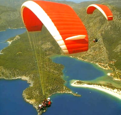
OLUDENIZ - BABADAG
Location: Mount Baba, which is on the province territory of Fethiye of Muğla city, is 7 km inside from the coastal line. It rises just after the Ölüdeniz (Blue Lagoon) beach and faces just towards to south. You can reach to take off runway via a 45 minutes from Ölüdeniz stabilize but nearly smooth road.
Flight Season: Secure flights can be performed between April and October.
Regional Characteristics: Ölüdeniz, which is the first place where paragliding is performed in Turkey, has a world - wide fame. Its unique nature, sun and sea is enchanting thousands of national and foreign tourists every year, and has a structure appropriate for all kinds of outdoor activity. There is no transportation, accommodation and nutrition problems within the developed touristic center, region. Yacht tours are also drawing attention in the area. Mount Baba is preferred as trekking and camping area during summer and winter.
Take Off Runways: There are a total of three runways in Mount Baba. 1700 meters high south runway is appropriate for take off. 1800 meters high north runway is a little bit small and upright. Take off area of the 1900 meters high north peek runway is very comfortable. As 1700 meters high runway is taking the south wind just from the opposite side during the most part of the day, generally take off is made from here. Approximately 20 wings can be lied on very wide runway at the same time.
Landing Runway: Belcekız beach at the coast of Ölüdeniz, is a long and very comfortable and secure landing runway with its width.
Meteorological Characteristics: During summer season, weather is stable. Sometimes during morning hours a north wind comes and take off is made from north runways into the valley. South runway faces a south wind, between 5 - 20 km. during most of the day hours.
Things that should be considered: Especially during the beginning and end of the season, climate change months weather can change rapidly and cloud can cover the take off area. On south runway, during the period till to the midday west wind coming from the west end of the mount, can create a false south wind and mislead.
DENIZLI - PAMUKKALE
Location: Pamukkale is at the feet of Mount Çökelen which is 21 km away from Denizli. As it is a touristik region all kinds of transportation is available to the region.
Flight Season: Flight can be made during all seasons with its warm climate.
Regional advantages: An ancient settlement region, Pamukkale is one of the most important tourism centers of our country where thousands of tourists are coming every year with its ancient ruins and travertine formed with the settlement of lime water.
There are two hills for take off:
Training Hill
Meteorological Characteristics: After sun rise, wind which can be sensed at south - west direction had blows mild till to the noon hours. Wind which increases its speed during noon hours slides to the west and nearly fully stops during sun set.
Take Off Runway: As 70 m high hill is low it is preferred for amateur flights. Due to the warm impacts of the underground waters in all of the region wind changes sensed within the region is not sensed here. By means of regular winds secure flights can be made during all of the year.
Landing Runway: Flights from the slope is ended at the plains of the region. Landing points are very secure due to not holding a handicap.
Things that should be considered: Though turbulence formed with the speeding up wind during the noon hours of the months when summer hot is lived most densely should be considered.
Dynamite Warehouse
Meteorological Characteristics: Hill, which is reign by western winds is especially appropriate for flight during morning hours. Strong thermal formations which begin around noon are maintaining long flights for experienced pilots.
Take Off Runway: Flight runway, which took its name from a former dynamite warehouse at the peek is 300 meters high. Slope which has a wide area for take off of two parachutes together easily, is at a point from where you can see all beauties of Pamukkale.
Landing Runway: Although you can land to the area at the end of flight track, you can also land securely to the helicopter runway at the entrance of travertine.
Things that should be considered: Turbulence formed during noon hours of summer months require maximum control and consideration during flights. You can face with turbulence at the end of take off runway during hard winds. Cross blowing wind causes asymmetrical close at parachute just after take off. Also ending of hill with high slope requires a very quick run for a successful take off.
ANKARA - GOLBASI
Location: Transportation to Gölbaşı region, which is 27 km. away from Ankara city center can be easily maintained from city center.
Regional Characteristics: Due to closeness to Ankara it is possible to benefit from all activities and possibilities within the city. It is the region where aerial clubs of universities in Ankara are training Paragliding . Gölbaşı, is also a promenade place which draw attention of Ankara residents who want get away from city life goes for weekends.
Take Off Runway: Training hill which faces to a wide plain is very appropriate for hillside parachute training due its appropriate altitude and facing wind from all aspects.
BOLU - ABANT
Location: Abant Mountains, is 34 km. south of the Bolu city center. Asphalt 25 km. long Abant Lake road can be used for reaching. Road transport to Bolu, which is on the Ankara - Istanbul highway passing is very easy. For reaching Abant Lake minibuses departing from city center can be used.
Regional Characteristics: Dense rain forests surrounded Bolu city is appropriate for all kinds of tourism activity. Abant Lake, whose environment has a rich plant cover, is drawing attention as a picnic and resort place during summers and an appropriate place for winter sports during winter. Abant Lake surrounding accommodation and nutrition possibilities can be benefited.
Take Off Runway: Abant Mountains have more than one take off runways appropriate for hillside parachute. Generally it is performed on the hills surrounding Örencik Plateau, near to Abant Lake, wide, plain and fully covered with grass.
EGIRDIR
Location: There are road and railroad transportation in Eğirdir, which is 60 km. away from Isparta. Local bus firms of Isparta are passing from Egirdir.
Regional Characteristics: Egirdir which is appropriate for lots of tourism activities with Eğirdir lake and island, has very appropriate hills for paragliding parachute. Süleyman Demirel University Aerial Club is performing training flights on these hills.
KAYSERI
Location: Ali Mountain on the territories of city of Kayseri, is 15 min. Away from city center. It can be driven up carefully. Or when you get off the bus at Ali Mountain plate with getting on to a bus, you can reach to the hill within 45 minutes by foot.
Regional Characteristics: World wide famous Cappadocia present, Kayseri is welcoming to thousands of tourists each year. Kayseri is serving possibilities to the other sportive tourism types such as skiing and cycling besides paragliding with its appropriate geography. Civil Aviation VIHE, is organizing training flights to Mount Ali.
Take Off Runway: It has an altitude difference of 600 to 750, and there are two take off runways of which one is appropriate to south winds and other one is north. Steep and smooth inclination of the hill is appropriate for hours of paragliding, but you should be careful in weathers with turbulence.
Landing Runways: There are easily landing areas in front of the hill.
ESKISEHIR - INONU
There are facilities of Turkish Aviation Organization within İnönü Province which is 15 km west of Eskişehir. North facing slopes of the province, are establishing very appropriate flight conditions with especially north winds during summer months. Courses organized by Turkish Aviation Organization are performed here.
ANTALYA - AKSU
Hill in Aksu province of Antalya is used as training hill by Akdeniz University, Avaiation Club. When you turn Perge ruins from Aksu turn of Antalya - Alanya road, and go for a 10 - 15 km. without entering Perge 40 - 50 m. high training hill is reached. Irrigation channel should be considered during flight.
Physical Conditions for Paragliding
For paragliding lower age limit is 16 and upper limit is 55. You can be flexible for upper age limit according to health condition. Kilo limit is minimum 40 kg, and maximum 130. Epilepsy, asthma, heart, waist and keel disordered persons can not participate to hillside parachute training. For participation to hillside parachute a form declaring that health conditions are appropriate is filled.
Parachute Types .
Parachutes (wings) have various sizes and types according to weight of the pilot and flight type. Parachute used by light weighted pilot, is smaller in size than heavy pilot uses. There are 5 types of parachutes showing different performances according to the training taken and experience.
Wing Structure
Paragliding can be investigated at 4 parts composed of Canopy (Dome), hook and break ropes, supporting columns and Harness (equipment).
Canopy It is made up of texture with no air transparency which will maintain parachute to remain in the air with supplying air pressure in the parachute. Canopies, is composed of approximately 40 - 60 cells according to the weight of the pilot and flight type, and these cells are connected to each other with valves for maintaining air pressure.
Hook and break ropes Ropes made up of a very resistant and light material are moderately to the canopy in order to support the pilot. Ropes in front of the canopy are collected on front columns and rear ones are collected on rear columns. Break ropes are different colored and they pass through a ring (they won't hurl even if pilot leaves them free) and place into the final column.
Supporting Columns Supporting columns, are connecting dome ropes to equipment. They maintain suitable holding places to pilot during take off. They give possibility to use different harness usage beyond easing take off. While there are accelerators known as speed system on less developed hillside parachutes, it is fixed to harness columns on some of them.
Harness (Equipment) It is part where pilot will sit. It is basically composed of hooks passing through feet and arms for equipment of pilot. Its structure can vary according to the used material and additional equipment. There are cross columns on some harnesses. These have a structure of directly transiting body movement of pilot to upper part for more securing the dome. There are speed system connections, back protector, air bag, spare parachute division like advantages of developed harnesses. All harnesses can be modified according to the body structure of the pilot.
Meteorological Information
For performing air sports securely appropriate weather conditions are very important. Basic meteorological information is required especially paragliding Movement of the wind and shapes of the clouds are the factors initially signing for flight. Other two factors are turbulence and thermal.
Turbulence They are vertical aerial movements. Turbulences; are faced during 5 km/h exceeding impact movements, specific geographic regions, with a wind backward coming to a steep hill, in thermal entrances and exits and front regions.
Thermal It is formed with the rise of warm air mass. This air mass composes flight hindering clouds with cooling, and this is also causes hard turbulence. Thermal is more formed especially in rocky regions, asphalt areas, forest region, water region (river, lake, sea ...) and agricultural areas.
POPULER TOURISM CENTERS
| ISTANBUL | ANTALYA | ANKARA | BODRUM |
|---|---|---|---|
| ALANYA | KUSADASI | FETHIYE | IZMIR |
| KEMER | CESME | MARMARIS | DALAMAN |
